Leveraging Drone Flight Services for Your City
Some of the neighborhoods in most cities are quite old, with houses dating back over a hundred years.
Given the age of the buildings in these areas, there is a general concern that they are not very energy efficient. City officials suspect that the older buildings do not heat or cool very well and probably leak hot air during cold weather and cool air during warm weather.
The poor energy efficiency in these older buildings presents not only a waste of resources but also a negative impact on the environment, given that the extra energy the homes use could be directed elsewhere or simply not used at all.
At the moment, city leadership is aware of the potential in energy efficiencies, and to date has used traditional methods in property assessments. These traditional methods typically require working at heights to access the roof and upper level facade areas, and do not provide a comprehensive visibility into a building’s condition. As a result, the City was intrigued by the opportunities presented with drone-based thermal assessments.
Using Drones to Reduce Energy Loss
When Winchester, VA became partnered with DroneUp in its Innovative Municipalities Project, helping the city become more green was one of the core areas of concern for its leadership.
As part of this focus, city officials wanted to see if the DroneUp team could use drones for energy loss detection in its older neighborhoods.
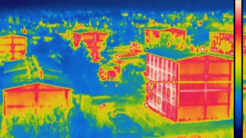
Toward this end, DroneUp leadership developed a plan to use a drone equipped with a thermal camera to capture thermal imagery of roof and facade areas for all the buildings in one of these older neighborhoods. By looking at contrasts in the thermal imagery between the inside and the outside, DroneUp personnel could determine whether each house in the area was leaking heat and potentially in need of upgrades to improve its energy efficiency. (In warmer weather, the same approach could be used to look for contrasts that indicated cool air was being leaked.)
The idea for using aerial thermography this way draws from similar work currently being done with drones for home and building inspections. This kind of thermal inspection work has the potential for industrial adoption. Power plants’ inspections have already tested aerial thermography for routine maintenance to finding energy leaks that the naked eye cannot see.
By capturing aerial thermography data around the roofline and facade of a building, drone pilots can provide inspectors with the data they need to make energy efficiency determinations and identify places where a building is leaking energy that might otherwise go undetected.
This initiative became the third of five tests undertaken as part of DroneUp’s Innovative Municipalities Project in Winchester. (The first two tests were covered over the last two weeks, and the remaining two tests will be covered over the next two weeks.)
The goal of the test was to see if a thermal drone could collect the data the city needed to identify energy loss in one of its older neighborhoods. Once that data was collected, the city could make decisions about how best to remedy the energy efficiency issues they found, including the possibility of using tax incentives or city payouts to fund home improvements that might mitigate the loss.
Results from the Energy Loss Detection Test
The test was planned for a Wednesday, but unfortunately, it rained heavily that day.
The rain made the test impossible. Further, the best practice for collecting thermal data from roofs is to dry the rooftop for at least three days before data collection. Since the entire test period for this effort was five days, this mandatory wait time meant that the energy loss detection test couldn’t be performed during the first wave of tests.
Despite the setback, city leaders find the idea promising and are intrigued by the idea of adding thermal drones to their list of inspection equipment. DroneUp has been working with them to find a good time to reschedule the test.
Getting Students Involved
The same day, DroneUp hosted an event with local students in Winchester (the cover image of this article was taken at this event).
The goal of the event was twofold:
- To inform students about the Innovative Municipalities Project and the work DroneUp was doing in Winchester, and
- To educate students about all the different ways drones are being used in the workplace.
This event dovetailed with Winchester’s larger goal of integrating drones into the city for economic development, education, and city improvement.
Most of DroneUp’s work in the Innovative Municipalities Project focused on the third goal—city improvement through drone use—but the student engagement event focused on the other two goals. By educating students about how drones are being used in the workplace and planting seeds for future economic development through drone entrepreneurship, DroneUp was hoping to ignite student interest in drone careers and STEM studies.
About DroneUp’s Innovative Municipalities Project
The Innovative Municipalities Project is an initiative created by DroneUp to offer drone flight services to cities to help them become more efficient while realizing significant savings.
The project’s core focus is to test how drones can help cities improve their work from one day to the next by leveraging drone technology.
Through close collaborations between DroneUp and city governments, project leaders identify and test custom-built solutions for each city’s unique need to employ advanced drones and software to help cities save money, improve efficiency, and, in some instances, keep people out of harm’s way.
Learn more about DroneUp’s Innovative Municipalities Project.
