Drone Services for Insurance Management Services – Rese Cleaver
Insurance companies are improving customer experience through the use of drone technology in risk and claims management. Consistently delivering speed and accuracy in claim resolution, drones serve as a critical component of the operational insurance ecosystem.
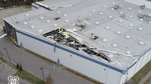
As an early adopter of drone technology, insurance providers deployed drones as part of claims operations — primarily for natural disaster damage assessment. The approach quickly exceeded market standard performance benchmarks and solidified drone technologies as standard tools.
So how do drones improve these operations? Well, for starters, drones do not require a runway to launch like other aerial vehicles. Their ability to gain access to hard-to-reach areas immediately after a disaster also provides immediate value to both policyholders and insurance providers. Faster response time and visual evidence from the flight’s data collection slice claim cycles to a fraction of the time.
Today, drone services for insurance management have expanded from downstream claims to upstream operations like risk mitigation. Organizations regularly using drone services benefit from reductions in loss adjustment expenses (LAE) and improved operational safety. These gains translate to improved customer satisfaction due to quick response times, and more often than not, lower premiums and deductibles.
Rapid Insurance Claims
Traditional methods for damage assessments require time, and it can be expensive to inspect a damaged home or asset accurately. Access to the property and good visibility to all damaged areas is not always possible through traditional visual inspection. The lack of visibility causes inefficiencies in the investigation. These challenges are driving insurance providers to look for new solutions.
How do drone services compare to traditional methods?
Traditional assessment approaches involve an adjuster driving site to site. Adjusters conduct as many on-site inspections as possible within the workday and are limited in the number of sites visited within that day. A typical roof damage inspection takes around two hours onsite. Moreover, this site to site travel contributes to roughly 50% of investigation costs in a Loss Adjustment Expense (LAE). The repair estimate with the traditional model takes about 11 days.
Now, let’s look at what an operation looks like using drones as part of the assessment workflow. The same roof inspection used as an example in the traditional approach above is about a 20-minute drone flight, capturing hundreds of high-fidelity images. With more loss data collected in less time, drone technology can conduct full-scale surveys, inspections, and hazard assessments — at a fraction of the cost. Drone deliverables capture comprehensive and high-fidelity imagery of the asset, uploaded and available to adjusters and inspectors to review in detail from any location. The same adjuster from earlier can complete around eight assessments in a single day. The timeline from claim submission to repair estimate, in this case, is around 4.5 days.

Comprehensive Risk Assessment & Mitigation
Insurance companies can harness the power of drone technology to conduct risk assessments before a loss occurs. After all, the most effective way to reduce cost is to reduce or eliminate loss opportunities. Drone technology can capture the current condition for structural assessments, inspections, and event-based risk assessments. This detailed snapshot informs policyholders and insurance providers and creates a benchmark record for future loss claim comparison. Through high-resolution aerial and thermal, visual data, drone technology enables subject matter experts to identify early detection of areas of concern. Additionally, because drones capture a comprehensive property view, unbiased and accurate reports provide objective information concerning event-based risks like floods. In flood risk analysis, these reports identify and classify the flood risks using elevation and hydrology assessments.
Fun fact – Because these assessments are unbiased, policyholders may benefit from lower premiums if the assessment findings classify the property at a lower risk than traditional assessment means.
Key Considerations
A few considerations must be taken into account when looking to add drone technology to assessment operations.
- Operators must use FAA certified commercial drone pilots on all procedures. This is a regulatory requirement, but also for competent operations with appropriate situational awareness.
- You’ll need insurance for the drone operations.
- Communicate with the property owner in advance. The benefits will quickly melt away if a property owner sees an unexpected drone flying around the property.
- Drone service providers often have a geographically dispersed network of qualified drone operators at economical rates. These providers usually handle liability insurance, background and credential management, and quality assurance.
To learn more about DroneUp’s Projects, visit our Research & Development page. For more information about our flight services and products, contact us.
Featured image taken by DroneUp Pilot user344061
